History: Thirteen years ago my athletic interests suddenly did a U-turn away from the cyclist/runner/triathlete world I was living in for the previous twenty-five years. During my 20’s I was a bicycle racing and training adrenaline junkie who craved speed and competition. I loved pushing the envelope on those two thin tires, and I savored each and every day I got the opportunity to either test myself against others or test me against myself. I craved the suffering you endure when biking at your AT. And in my 30's and early 40's I grew to love that same suffering feeling in running, swimming and triathlon. Back then all the training and competition helped to make my life very fulfilling. Then in 1999, on a whim, I did a self-supported cycling trek around Iceland on a mountain bike...and BANG a switch was activated in my brain. By the year 2000 the activation of that switch pretty much spelled the end of my racing days. Mountain biking across Iceland taught me there's just as much thrill in adventure as there is in racing. It also got me thinking about how many amazing adventures lay out there just waiting to be discovered. So began my infatuation with adventure, and so to began my love of mountain biking. I grew to relish the solitude of biking on woodland double and single-track, of cruising along secluded backcountry gravel roads, and of meandering across mountain meadows for mile after endless mile. It was both mystical, spiritual and therapeutic, and it gave me a real sense of peace and solitude. It was like “church on a bike,” where I could completely loose myself in the moment, where I could just get away from it all yet still be connected to a bicycle. To to me that rather unique combination equated to a Cycling Utopia! So I ended up doing this 180 in life, leaving training and racing in the past and moving into the world of athletic adventure.
From the year 2000 and onward, I ended up traveling all over the world, mountain biking, backpacking, climbing and mountaineering, and just exploring this big beautiful planet. Anyway, I conceived of American Dirt back in 2009 while on my first trans-continental cycling trip, a 6200-mile traverse of Canada. On that trip I used a 29er mountain bike so we'd be able to get off the beaten track and onto gravel roads and crushed limestone trails. On a gorgeous sunny day, during a stretch of single-lane gravel road in rural Quebec, the American Dirt idea popped into my head. "Wouldn't it be something to actually ride all the way across the country on stuff like this," I though to myself, "day in and day out, away from traffic and the hustle and bustle you find on concrete and asphalt...and is it even possible to do such a thing?"
2009 Trans-Canada Trip
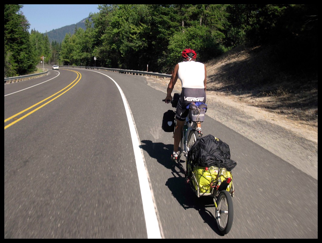
Once home from Canada I began to dabble with routes across the USA that might yield the best chances for a soft surface crossing. But in reality I was just way, way off of actually coming up with a viable state by state path. My subsequent 2010 Trans-USA cycling trip was a kind of recon trip to check out the availability of dirt/gravel along the corridor of what is called the Northern Tier Cycling Route, from Maine to Washington state. The Northern Tier Route turned out to be far too sparse with respect to soft surface roadways. So back to the drawing board and on to the next recon trip - my 2011 Trans-USA - where I was looking to connect some of the nation's longer rail trails with gravel roads and single track/double track. I did that 2011 crossing on a 29er, pulling a whopping 75-80 lbs of gear in a Bob Ibex trailer. And it was a total killer on dirt and gravel! I found that no matter how bloody strong I was, there were just some soft surface roads where the grades where so steep I couldn’t even walk the bike up them. That was a humbling trip indeed. That's where I realized that any American Dirt attempt had to be support in order to eliminate carrying heavy gear on the bike
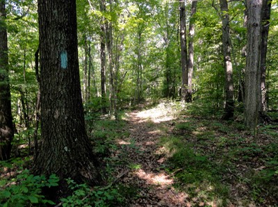
But on the positive side, I did discover a network of rail trails and hiking/cycling trails that form a staggered, very broken line across the country. Link those together with gravel backroads, jeep track, ATC trails and ancient RR lines...and abracadabra...a route could be born! So I was definitely onto something by stitching together a rough route with the information I'd gleaned from that 2011 trip. Next up was my 2012 crossing, when I had support, plenty of time, and about as much logistical research and equipment as I could hope to have mustered in three year’s time. But what I did lack was patience! Now in hind's sight, creating an American Dirt route back in 2012, with me riding across the US and doing recon at the same time, that was pretty much impossible. I just didn't get it yet. I was still too impetuous and not willing to slog through a few more years of recon sabbaticals to firm up an iron-clad route. Doing it on the fly was analogous to playing the lottery: there are probably a thousand million potential WRONG combinations, and finding the right one or two that would actually hit – that’s striking it rich. That’s one in a million, with the the odds slanted ever so solidly against me. My approach had been more from the heart than from the head, yet working AD while riding across the country was providing me with a life’s worth of personal satisfaction and several life's worth of amazing on-the-road experiences. I had fallen in love with the spontaneity of ad-libbing the route finding process. It just wasn't a prudent use of time, energy...and money!
Well again, I made it across the country, 3710 miles from DC to Oceanside, CA in 59 days - with zero days off no less. But I still ended up being light years away from actually accomplishing my vision of American Dirt, having managed only 1700 miles of soft surfaces out of all those miles of riding. The physical difficulty of that journey was exponentially tougher than the previous two. Ditto for the mental difficulty, the equipment, the logistics, the terrain – ditto, ditto, ditto, and more ditto. And this was without dragging a trailer and gear. This was WITH support! Having said that I can point to three glaring issues on this trip that contributed to me not attaining my goal. The first had to do with my decision to “cheat” through certain sections by riding on the grass and gravel berm of asphalt roadways. These I’d figured, might make it easier to reach the west coast with a “pseudo-AD route that would lie well within my three-month timeframe. And so this I did for 17 days of riding, managing to get from DC to Ohio's Hocking Hills State Park on soft surfaces, save for a couple miles of pavement on super dangerous descents where I had no choice but to walk. Yet I came to the realization that the “cheat” parameters as options were were just so slow, so laborious, and so treacherous that we still couldn't stay within our trip's time parameters. I had struggled up and down countless berm climbs either pushing the bike or climbing and descending in weeds, rubble, gravel, or down inside of ditches, that I ended up creeping along at 25 miles per day. Yet far worse than the snail's pacing, actually the crux of the berm issue, was the fact that it severely diluted the true vision of the trip. Anyone can ride berm across the country, no matter how hard it is! I wanted to be away from pavement. So not only was more recon necessary, but I also had to accept the fact that doing recon WHILE crossing just doesn't work, because making on-the-fly compromises becomes far too easy.
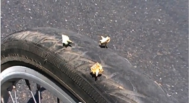
The second issue came out of nowhere, taking me by total surprise. I'm talking flats, loads and loads of flats. The culprit was a tiny three-spiked seedpod that ruined every tire and tube I’d had, and ran my four sets of patch kits down to empty within days. Upon entering western Kansas I was flatting three-four times per day, all due to the notorious “sandbur”. To say this was frustrating is an understatement, because it was such a maker-breaker of a detail that I’d not even considered through all of my trip planning. It was from out of left field and it was formidable. My dirt riding suddenly ground down to a halt until I could get the proper equipment with which to deal with the burs. That meant we had to drive half way across CO before I could get to a bike shop that would have the right gear. And once I did get to a big city bike shop in Pueblo, I found out I was still SOL. We came to learn that the infamous sandbur is an imported species of plant that now inhabits every square inch of terrain that lies in the 4000-7000 elevation range. Worse yet, these little beasts can be found from western Kansas all the way to the West Coast. Many billions of thorny sandburs litter dirt and gravel roads and all dbl/single tracks. They're a big deal out west for cyclists, and there are various ways to address them, but no one could come up with an answer for me what with my spending 6-8 hours per day riding through sandbur territory. Riders just don't "dwell" in sandbur territory for such large chunks of time. If they did they'd use clunky and totally unsafe solid rubber tires, which is what was recommended to me! The sheer quantity of burs imbedding in the tires, sometimes up to 100 per hour, rendered all the standard choices useless. And I'm talking tubeless wheels with slime sealants, tubed wheels with kevlar inner liners, rock-hard armadillo tires and thick, thorn resistant tubes, all of them useless when it came to hours of constant sandbur impregnations.
What with all the sandbur trouble and the subsequent new set of route logistics to consider, I was in a complete quandary with respect the next direction we’d go. Prior to reaching Limon, Colorado the logistics issues were pretty straight forward and pretty simple – we'd use soft-surface tracks that paralleled the interstates such that we had easy access to support and communication. But west of Limon, support logistics became exponentially more difficult. No longer did the dirt tracks parallel the interstates. Many of the tracks drifted far off of parallel. And ten to twenty miles north or south of the interstate meant no cell-service and no opportunity to make emergency calls for vehicle support. What’s more, a high percentage of these soft-surface roads were totally out of the question for girlfriend Judy to drive my 8-passenger van on for support. This turned out to be our third and final problematic issue. From my mapping experiences in Missouri and Kansas I had learned this: it may be listed as a road; it may look like a road; it may have a name like a road; but in reality it may be nothing more than an primitive path or a rutted out ribbon of double track, a track accessible only to motorcycles, ATV’s and beefy 4-wheel drive vehicles. The savings grace about Missouri and Kansas was the fact that the van would be a mere 1-5 miles away on a paralleling interstate, so I was always within support distance no matter how bad the track. Not so from Central Colorado westward.
So couple the sandbur issue with the support issue and I found myself in a pickle as to deciding whether or not it was prudent do the second half of the trip on truly remote tracks through mountains, high plains and deserts. And no matter what direction I decided to take, be it north across Wyoming, Utah, Idaho and Oregon, or south across New Mexico, Arizona and California, I’d still have sandburs and support as monumental obstacles. Couldn’t get around that fact that I was down to two choices: either be truly unsupported with the prospect of a flats looming each and every minute, or take a chance with Judy following me in the van on remote and unreconed dirt tracks. In the end my decision was do do neither. The harder decision was realizing that I'd have to do the rest of my riding on asphalt. I was just too unprepared for the burs and could not afford to rent a 4-wheel drive for a support vehicle. But let the truth be told, by that point I was fried, burned out, tired and wanted nothing more than to finish the trip. So even when we were next to frontage roads that were gravel, dirt and sand, I opted for the asphalt only because I could go faster, ride easier, not flat, and finish quicker. I'm sure I could have tacked on another 500 miles of soft surfaces to the trip’s total. But at what cost what with the flats and down time? So we ended up taking the southern route on paved roads to California, into new territory for me with respect to riding X-country.
But mind you now, riding asphalt through New Mexico, Arizona and California in the dead of summer wasn't a picnic. Never had I ridden in such severe and constant heat, and believe you me I'd experienced several major heat wave riding bouts on my previous 2010 and 2011 trips. Well, welcome to the Mohave Desert! The heat was so otherworldly on this trip I was forced to get a jump on the sun by waking up every morning at 3:30 AM and being on the road at 5:30 AM. I’d get in 3.5 hours of tolerable riding amidst 80-something to 90-something-degree temps. But by 9:00 AM, when the sun was higher and the temps had soared to well over 100, it became "Welcome to Hell" cycling. That's when the remainder of the day's ride became sheer survival. I liken it to riding next to a smelting plant's blast furnace for hours on end. Cashing it in would have been so easy to do each and every day. But I knew from past experience that if I just went one more day, and then one more day, over and over and over again, I'd finish, and be damned proud of the fact that I didn’t give up, no mater how far off of my goal I was. That’s why and that's how I finished my American Dirt attempt in 2012. It wasn't pretty, it wasn't pleasant, and it wasn't even half completed, but it was another in many small steps towards future success.
In 2013 I decided to learn from my previous year's mistakes, buckle down, embrace patience, and dedicate the following 24 months to nothing but melding my at-home research with my on-the-road recon trips to firm up the best possible route I could create. First and foremost I want to wipe the slate clean of the majority of berm riding I'd done in 2012 and replace it with real, no-nonsense soft-surface tracks that I'd either ride, bikeahike, or canoeabike. Period! Second, I needed to figure out the sandbur issue such that I could ride for hours on end across those cruel little biological tacks and not end up changing flats every hour on the hour. And third, I figured I'd need to have my van driven on the gravel backroads and jeep tracks once we get to Colorado and beyond such that I can receive support when riding in some of the more remote regions of the United States.
During spring/summer of 2013 I was able to do enough home-study and recon trips to get the route pretty dialed in from Washington DC all the way to the Mississippi River in western Illinois. I'd cut the berm riding down to more swallowable sections that were absolutely essential, otherwise I'd be forced to ditch sections of route that span a hundred or more miles at a time. I'm just going to have to let that one little issue wait for future adventure mountain bikers who might want to take up the torch and complete in full what I've created in “rough outline form". I did another winter of home-study with maps during the winter of 2013/14, and then In the spring of 2014 I further extended the starting point from the Potomac River in Wachington, DC all the way to the Atlantic Ocean along Delaware. Then, in the summer of that year I traveled west and reconned the route across Colorado, Utah, Nevada and California.
In 2015 I did the trip and managed to get from the Atlantic Ocean in Lewes, DE to within a hundred miles of the UT-NV border. You can go to the blog page for a day by day of the journey. Today, as I write this on 4/23/16 I’m 5 days away from driving back to our finish point in UT where I’m hoping I can ride the last 1000 miles to the Pacific Ocean in Northern California.
Rules/Logistics
THE RULES: Hey, it’s my gig right? And I think I have the right to create my own rules here! Now ideally I’d love to do this whole thing on soft surfaces from the East Coast to the West Coast without ever touching one iota of asphalt or concrete. But realistically, that’s bloody impossible if you take the statement in its most literal sense. Take for instance when a trail, track or gravel road crosses an asphalt road? Do I ride across it, stop and carry my bike across it, hop across it, or just not cross it? Well, as I've done before I just ride over these hard surface crossroads and accept them as no harm, no foul. How about the bridges?
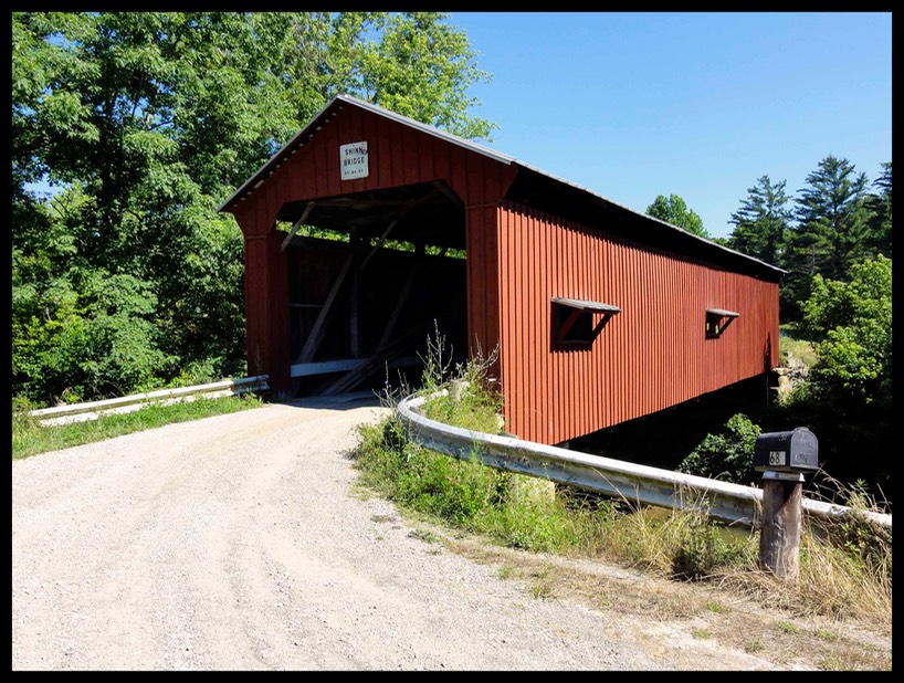 No not covered bridges, those are few and far between. I'm talking about those steel & concrete behemoths like the ones over the Ohio and Mississippi Rivers? I’m sure as heck not going to backstroke them with a bike on my belly. I used a solo Old Town canoe which we carried on the roof of my van such that I could paddle across large rivers and streams with a collapsable bike on board. In the end I guess it comes down to how litteral you want to be about staying off of hard surfaces. Paddling with bike on board was actally a really fun experience and I’d highly recommend it for bridging through really urbanized areas where soft surface cycling is impossible. I did this on the Potomac River in order to avoid the highly urbanized Washington DC area.
But honestly, bridges are low on the rules list. The real rule testers are all the areas that end up offering no way to continue the route. These are places where there’s only one option to connect two bomber sections of soft surface route, and that means riding on the grass/gravel berm of a paved road or paved Rail Trail. Oftentimes such "impediments" to the route are merely a few short miles of asphalt roadway or Rail Trail that end up separating twenty, thirty or even a hundred or more miles of soft surface track. I call those situations my CP's (compromise points) because they are the only alternative other than trespassing on private property by bike-hiking. So yes, short CP's on gravel berms were fair game in my rulebook. What I did not want to do was just give up on the ethics and ride berm for miles on end - all the way out to the West Coast. That I think is pretty much cashing it in and copping out on the true vision of the trek.
Now I didl ride on hard surfaces when I was heading back to a campground or motel after a hard day’s ride on dirt. As long as I was not using pavement to progress forward on my trip I was good. I would also ride on pavement if an intended route went sour and I had to return back to a specific start point where the route was last true to the nature of the trip. It was a real mind game going over these scenarios.
THE MAPPING LOGISTICS: T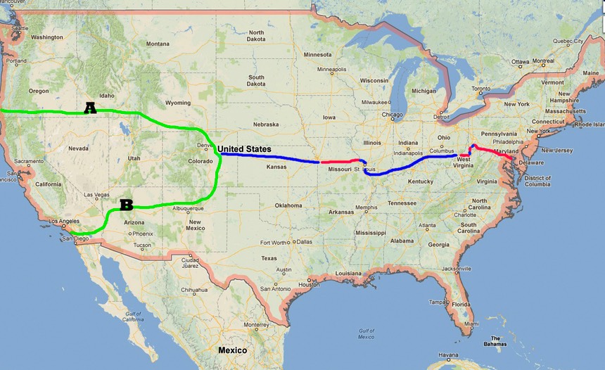 his aspect of the trip is exponentially tougher than the physical training. I’ve been buying and digitizing maps for the past six years. Today this collection is amazing. I had to purchase two 1TB external drives for my desktop computer just to store all the digitized maps and the flow of photos and videos that I've generated over the the past several years of work. At last count I have 37 state gazetteers, not to mention a five-foot high, fifteen drawer map cabinet filled with numerous state's county roadmaps. But despite the plethora of route information all is not well in the mapping world. I’d be remiss if I didn't reveal that many of the maps I've counted on for reliable information have not been updated in decades, despite the fact that they may be labeled as reprinted in 2011, 2012 or even later. Seems more often than not many of the county DOT's just keep reproducing maps with no amendment to the road systems. It’s crazy. Ditto with anything that’s on google maps. And honestly, Google maps can actually be worse than county roadmaps. GPS information you might ask? Don't always count on that either! I found all this out the hard way in my Trans-USA 2011/2012 trips when I ending up running into a rat's nest of dead-ends, hunting for nonexistent roadways and getting lost in the middle of private property amidst a gazillion "NO TRESPASSING" signs. For this reason and this reason alone I knew I just had to recon the route in-person in order to either verify or dismiss my previously mapped information.