
Tuesday, June 9: Definitely an “American Dirt” day with all the degradation!
Morning started from downtown Rochester at the end of the Nickel Plate Trail. Now at the end of this trail is this old, but active feeder line which is just the continuation of the same RR line. Now it looks more like a line to park RR cars on. And today, that was indeed the case. I couldn’t just ride on the thing as I’d planned cuz it was just one long line of tanker cars, so I had to ride berm for a block until the parked tankers ended. Then I jumped on and rode through downtown Rochester. In most of the downtown areas I was able to just ride on the right side of the tracks on the ballast, trying to look like some mt biker dude who didn’t want to ride on the road. And really this is not a RR where there are active traffic coming and going. So I got through town and then I knew I’d have to take a left when the tracks branched off…and be damned if I didn’t miss it. So I was just riding down the middle of the RR tracks on these bumpyier than hell ties, and it just kept going with my feet flying off the pedals constantly due to my wearing hiking shoes. Finally stopped, looked at my gps and found that I’d screwed up. So rather than ride all the way back to the Y, I rode to 200, did a right on berm and then got on Old Rt 31 and did a left on some great sandy berm. Took that back to the intersection with the right line. Got on this nice old ballast and took that for a stretch, and then I got on some parallel double track along the old RR grade. Called Judy and told her of my gaff, then continued on the double track.
That ended at this abandoned RR station and some abandoned grain silos. From there were more parked tanker cars on the RR. Now I knew from recon that this line dead ended at New Rt 31, and that’s where I had to get to, so I just kind of rode in the weeds along the tanker cars. But the weeds gradually got thicker, and gnarlier and higher. I finally got to the point to where all of the above converged to the point to where I couldn't even ride. Had to get off and push. So I’m pushing away, using my bike as a bulldozer through all the vegetation and then I come to these thickets of prickers and wild rose bushed. And let me tell ya, these pups were like fortresses. So I had to crawl under the tankers and kind of drag my bike to the other side to have access to forward progress. This happened 2 more times for the same reason.
Now these cars were NOT connected to an engine, this I knew from the fact that I rode by the start of the parked cars and I knew that the other end of the old RR line, I knew that was a dead end. So these guys were definitely parked. But I will say it’s an unsettling feeling crawling under those monsters with the RR wheels just feet away. Then there’s the getting the bike under the damned thing. Kind of had to drag it in stages, trying to keep it no higher than like 2.5 feet high. So I did this traversing to get by all the briar patches. And even when I did bypass them, I was still pushing the bike through small patches of prickers, nettles and rose bushes. I’d gotten myself in so far that I was committed - that’s about the time I thought I was a complete and utter idiot for doing what I was doing. I was just chest deep in shit for a half mile of bushwhacking. Then when I saw light at the end of the tunnel - the end of the line and the sounds of traffic on New Rt 31, I found that there was this barbed wire fence up. Had to lift the bike over that, then get me over that, then push the bike up this long and steep incline where at the top was the road.
In hindsight I could have done a berm ride in 1/8 the time on a parallel county road. I was just soaked from all the water on the plants from last night’s rain storming, and I had bugs, seed pods, burrs, prickers and all kinds of crap on me as I popped up on New Rt 31. Not only that but my legs were burning like they were on fire - that the result of all the nettles I’d wadded through. Must have looked like some vagrant popping up on the road! Went south on New 31 for a couple blocks and then went left on 100N to meet up with Judy. Got to the van and literally rung out my soaking socks, then changed to my cycling shoes - I was smart enough to wear my hiking shoes on that last section. So we started moving west on small county road berm.
I’ve had to revamp my itinerary for today and the next several days to to the huge amount of rain this area has gotten in the last 2 days. All the streams, creeks, run…and RIVERS are just engorged with water, looking like wild angry rivers. So my plans to do some paddling with the bike on board, that’s out the door. There is no way in hell I’m putting that flat water boat in these flood waters. So I’m left with plan B: county road berm or active RR lines. I had to go with the county road berms. I would have paddled some of the Tippecanoe River today, but as I said these rivers are bubbling caldrons right now. So from 100 N we went onto 200W and then 200N and then left onto Olson Rd. The berms of these roads were great, to good, to fair, to poor, to rotten. So I had a great mix! Once on Olson the berm was actually pretty good So I could get in about 8-9 mph.
Did a support stop in Leiters Ford, and the we were off on Olson Rd again to the town of Delong. Then we be bopped a bit doing a right on Rt 17 berm, left on 650N berm, right on 1100W and then left on 675 N. Took that last one to junction with this little Erie Monterey Trail. That was paved of course so I rode on berm yet again. Met Judy in the small town of Monterey for a final gameplay. I was to go off road the rest of the way so I needed to get Judy to the next available trailhead, the North Judson Trail. So I gave Judy the directions on where to meet me.
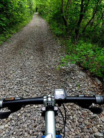
Now what I’d been doing is following the same old abandoned RR grade that had the tanker cars parked on it. Some of it does not now exist, but there are sections here and there that you can still see the line and ballast, or even the ties and rail - and a lot of that is the proverbial jungle. But in Monterey, the little trail section is part of this abandoned line, and from Monterey to the North Judson Trail, I found from recon that it’s accessible to me biking it on a 29er. So I just went around this grain silo at the official end of the Monterey Trail and there was this double track that lined up perfectly with the Monterey Trail. Off I went and off Judy went. So this thing went from double track to single track, to bike hiking around deadfall and briar patches - shoot deja Vu! But then it took me out to this gravel road - 3-Mile Road, and I took this to the right and just rode like heck on a wonderful section of winding gravel road.
This took me to where the old RR line went across a big abandoned RR trestle across the Tippecanoe River and back onto more abandoned line. But from here onward this stretch has signs posted calling this the Federal Rail Bank Trail. Now it’s just old ballast with hip high weeds growing on it, but it’s ridable, and it goes all the way to the end of the North Judson Trail - the very same RR line. This guy was a good 4 miles of bumpy, rugged, physical riding, but I was still able to get it rolling at 8-9 mph most of the time. Had to stop several times to carry the bike over deadfall, but by and large it was totally passable on a duel suspension mt bike - especially one like mine with 29x2.4 wheels.
I knew I had to X 3 county roads and then my next would be Rt 35 where the North Judson Trail ends/begins. Last mile of the Federal Rail Bank was just tough as hell, a bumpy jolting ride, but made it out of the heart of darkness and landed at the North Judson Trail - as I watched Judy drive by in the van. As soon as I got to the trailhead I called her and told her where to come - and she passed it again, with me kind of yelling out to her in frustration as she passed. Well, I’d pretty much pissed her off with that rant - which she heard through the open window - so we were bickering once we got back. Not going to go over the whole “bicker fest” but we eventually got it ironed out once the day was over. Final conclusion was that Pete is an A-hole!! And I agreed!
Had one last segment for the day, this the North Judson Trail to the city of North Judson. And it was pretty weird, cuz the one side of the trail, my right side had this wonderful flat, hard packed gravel berm, and the other side was like 6-8 feet wide beach sand. I stayed obviously on the gravel and was able to keep it at 10-12 mph, a very, very quick pace. But it slowly that degraded for about 4 miles to where there was all this overhanging crap I had to contend with. Some places were just choked with vegetation, and when I did get the kahunas to go to the other side in the beach sand, I would sink in the sand and pedal at like 3-4 mph. It was just maddening.
The last 4 miles were great when the gravel berm was on both sides. Made it to North Judson with 42 miles in for the day. Not only that but I think we can make IL tomorrow. So we got a little motel in North Judson where I could wash my still stinging legs and “debug” myself with a hot shower. Man I was just a mess from all the bushwhacking and ballast riding today. Weather takes a turn again for the next week, with rain in the forecast each and every day. I’d wanted to paddle at least 30 miles of the Kankakee River, but with the recent spell of heavy rains, that’ just not in the cards for this trip. I’ll look at some feeder lines that parallel the river into IL, and I’ll look at county road berm. Just too bad that the rain has coincided with this trip, but I have to adapt and make something work. Hell, I got this far, and by God I’ll get out of IN and into IL somehow, someway!