
Monday, July 20: Man, I can’t remember how many times I’ve said in these blogs, “don’t get complacent and think you can just do a day in cruise control, because &$^$#@ happens!” And that was definitely the case today.
Had more of a leisurely attitude today as we did yesterday, seeing that the temps, the terrain, and the route was all pretty good/easy. No need to beat the weather, no need to worry about surmounting passes, no need to worry about a boat load of climbing. I had it figured that today would be another one of those transitional days as was yesterday where I’d just cruise over the table top terrain in very comfortable temps for 60 miles of “fun & casual” riding. NOT!
Got going out of the sack about 6 AM, worked for a bit and then Judy and I went to That Place restaurant for another great breakfast. We both did a carbon copy order from yesterday: her getting the real oatmeal and me getting that massive breakfast burrito. The owner’s wife waited on us again, and was as friendly and hospitable as ever. I was just overwhelmed by the quantity of food, and when we walked out I was sporting a nice little Buda belly! Judy drove us back to yesterday’s end point, the junction of Rd R and Rd 15. Went on a small litany of gravel roads to work my way west to the UT border. This is the order: R, north on 15, to a L, west on Rd M, to a R, north on Rd 14, to a L, west on Rd M, to a R, north on Rd 13, to a L, west on Rd J. Now up to this point the road signs jibbed with both Judy’s and my gps’s. Now the only real surprise, based on how I stared the day’s blog, was that this was NOT easy table top riding.
Oh no, I was hitting roller after roller, and not just little punchers, but these steep power climbs where I had to drop into the little ring, and I do mean the little ring. Ok, so much for the nice and easy, casual riding on the table tops. This was just one roller coaster after another. Damn was that a slap in the face. Judy even kind of ribbed me about the “easy riding” that I had anticipated quite openly to her about. So that was the first surprise for the day. Next up was the fuzzy situation of our gps’s and gazetteer suddenly not jibbing with the the road signs. And I mean these guys were miles apart.
We first noticed that when we needed to go R, north on 9 from Rd J. And suddenly this stuff is labeled on the sign as Rd. 9.3, 9.7, Rd 9.9, and so on. There was no Rd 9. So we made a wrong turn on a dead end where I thought we may still be on the road, but it had deteriorated into a farm field, just as some of the KS roads had done. This thing looked ugly for the van, so I sent Judy back to the main roads where she would take those to meet me about 10 miles away. I’d stay on this dirt, rutted out dbl track and see what happened. Well, it just got fainter and fainter until I was in a wheat field with nowhere to go. Ok, then back to the junction with Rd J where I continued, and then it took this dogleg to the R, and changed names….BUT not according to my garmin. At that point all I knew is that I was riding to the west because my shadow was directly in front of me. So I just continued on this ambiguous road.
So I went another mile, heading towards Dove Creek, CO, and then I see this road sign, where I should be doing a R to go north, and it’s labeled Rd 8.7, but my gps says it CR 9. I go for it, knowing this has to be the Rd 9 I had to take a right on. And this puppy wasn’t kind to me, having a lung crushing little cookie climb on it that just went on for what seems like forever. And it just kept going for miles. I knew I had to look for a L, west on Rd E, and eventually this CR 9 did a hard L and wasn’t labeled at all. My gps told me it was E. Ok, good so far. Next up should be a R, north on Rd 8, but again, I get to this junction and the sign says Rd 7.7. What? My gps tells me it’s indeed Rd 8. So I took the R. And finally I had to look for a L, west on Rd C, and….surprise…it was labeled Rd C, and jibbed with my gps. So I took this several mile to meet up with Judy who’d been waiting not the 30 min I’d told her, but more like an hour.
We talked about the weird road sign labeling, and the garmin we use in the car was just like my gps - it jibbed with the gazetteer but not the signs. Anyway, we were good to go to push into UT. This Rd C goes west across the UT line, and it stayed gravel dbl lane for about 2 miles - again, with nice steep power climbing - and then you enter UT and the road narrows down to single lane dirt and changes name to FR 336. And I mean it’s big time dirt. Now my gps called it Old S Highway, as did Judy’s, but at least this jibbed with our UT gazetteer - the Benchmark Maps UT Road & Recreational Atlas. We used this same gazetteer for CO, as opposed to the gazetteer put out by DeLorme because the Benchmark Atlas gives you a delineation between dirt & gravel & 4WD roads and asphalt roads. They are invaluable for this trip, and though CO the Benchmark Atlas was spot on.
OK, at this point, where we entered UT and the road changed to single lane dirt, Judy had asked a guy in a pick-up if the road was passable, and he indicated that it was. So we continued on with her driving several miles ahead of me and stopping at the junction points in the route. I kind of held my breath for those 7-9 miles in UT with this road because it was just entrenched in the red dirt in places, where if there were some clearance issues up ahead, we’d be in a pickle for sure. But, since it was so dry the road was definitely passable for the van and we made it quite easily. Our next turn was a R, north on CR 313, West Summit Rd, which according to the Benchmark UT Atlas is supposed to be gravel. It was not, it was asphalt.
“Ok,” I thought, “maybe it will change in a few hundred yards or so.” Well it did change in about a mile to back to gravel. But then within another mile it went back to asphalt. And the berm on this thing - NO BERM. It’s just weeds and rocks on a 40-degree angle, so there was no berminating here. I took it in stride figuring it would go all gravel soon. It did not, and as the miles rolled on I got more and more frustrated. This was THE, and THE ONLY way north to hook up with the rest of gravel routes up north closer to Moab. Mile after mile of asphalt, and right there on the gazetteer is the route in horizontal hashed lines indicating gravel road. I stopped Judy a couple times to look at the gazetteer to see if I made a mistake in the route, but it was dead on correct - only it was asphalt.
Now at this point my options were really nil, because I’d done all that previous riding to set myself up for this push north into the canyonlands area. I had nothing else to fall back on. So we continued, we me hoping that this thing would indeed go gravel somewhere down the road. It never did. My next turn was a R, east on Bryan Rd/CR 324, which is also supposed to be gravel. Nope, it was asphalt to. Then there was the L, north on CR 370/Ucolo Rd/Rt 4430, and be damned if that to was asphalt when it is labeled in the gazetteer as a horizontal hashed line road. By this time I had a tantrum at the van, and Judy calmed me down by telling me that there was nothing I could do. I probably uttered about every foul word in the English language as I stood there staring at the gazetteer.
You see when I did recon on these western states I did NOT drive each and every road, rather I jumped around checking out the road routes at points every 20-40 miles. This way I could cover much more ground by driving on asphalt, and then get off and check out junction points with my gravel route. This saved me a ton of time last summer. So I did not drive these three roads, and there I was SOL. My UT gazetteer was worng, and that’s got me pretty worried right now.
So the situation was further complicated because my gps called this road Lisbon Rd, not any of the CR 370/Ucolo Rd/Rt 4430 as indicated on the gazetteer. Judy’s garmin called it CR 370, so that was about the only bright spot. I had to keep riding, and did the big descent down into a canyon where there was this major mining operation. And this thing was major, with open pit mines all over the place. All I can figure is since the gazetteer was made, the first edition was 2002, and my edition is 2014, that they have not updated some of the road information since 02. And with this mining operation, the roads were paved to accommodate all the heavy truck traffic going in and out of the mines since then.
And there I am completely stuck. Just continued down the descent, and then up this really long gradual climb for about 8 miles. I could churn out a great pace, but that was not a good feeling for me as I was doing it on asphalt. Finally, at what I intended to be the end point for the day, I just threw the bike in the van in utter frustration and we headed south to find a motel in Monticello, UT. My options without these roads being gravel is nil. I have no options out here, as that WAS my gateway to the La Sal Mts and the western canyonlands. I’m going to have to really work tonight to see what I can do to reconfigure this thing and salvage the route. I have a feeling I’m be doing some berminator on Rt 191/163 north. For the 30 miles of asphalt I did today….I guess I’m just going to have to take my medicine like a big boy and live with that. We’re so limited on time now that I do not have to time to take this thing all the way back to CO and do a total reconfigure to get us to where we’re intending on going. I really don’t even know if it’s even possible out here what with all the canyons, washes, arroyos and rocky escarpments that you have to go around, down, through and over. Travel avenues are really limited at this point.
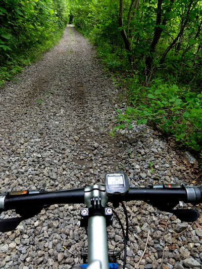
Ok, enough of the weep-wow stuff. Here’s the day’s stats: Covered 68 miles with just under 4K in climbing and I burned - according to my garmin - app. 4000 calories. As far as location for today’s end point of the ride, we’re probably about 30 miles south of Moab.
We got a little cheapie motel in Monticello, UT, and had a very nice dinner at a little cafe down the street. Got a nice dinner but I’m still hungry - the curse of riding all day. I’ll likely nuke some of those “spicy dogs” we still have left from when Bill was with us. Mmmm Mmmm good. Bring on the dogs!
I have to get my stitches out of my right leg here today or tomorrow, and it looks like Moab will be the place to do it. I’m hoping there is a CVS or the like there which has a nurse-practitioner on the premises to do the deed. Otherwise, I’m going to have to buck up ($$$$) with a med center for the procedure. Until tomorrow….